 PeteFree.com
Mount Sherman (14,036 feet) — A Review for Hikers with Joint Disease, Joint Replacements, or Neuromuscular Deficiencies
© 2012 Peter Free
10 September 2012
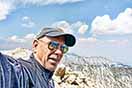
View from the summit of Mount Sherman, Colorado, taken 06 September 2012.
This review of the southwest ridge “standard” trail up Sherman is for people with joint disease and/or mild neurological problems
You can gauge the relevance of this review to you by reading an overview of my mild physical impairments, here. Notice that I have had to give up non-steroidal anti-inflammatory drugs (NSAIDs), due to hypersensitivities.
People with joint disease similar to mine, but who can treat it with medication, will be able to go longer distances than I do, with significantly less difficulty.
Allegedly “easy” Mount Sherman wasn’t
I preferred five of the six other “fourteeners” that I have written about, despite the fact that they are significantly longer walks than Sherman.
Mount Sherman gets its “easy” reputation from being only a 5.25 mile hike (along the mountain’s southwest ridge). For able bodied people, the characterization is deserved.
For me, the mountain’s interminable carpet of small rocks and gravel became a major detractor. I preferred the prior week’s twice-as-long Mount Elbert route, even with its tediously long cover of loose (mostly) larger rocks.
The difference between the two hikes is my susceptibility to balance difficulties on rocks of the Sherman size.
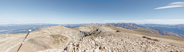
Here are three photographs of what I’m talking about:
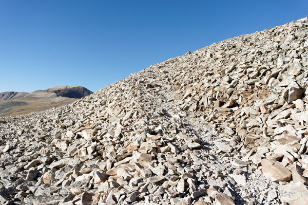
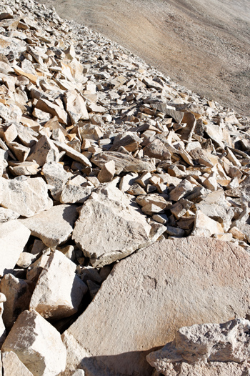
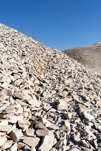
These smaller rock sizes tend to slip, tilt, and slide on a relatively high proportion of footfalls. People with good dynamic balance have no difficulty.
But people with a combination of joint disease (including joint replacements) and neuromuscular complications will probably have a hard time making sudden adjustments to balance.
In my case, the balance problem worsens because (off-balanced) my legs go into reactive spasms, which work against the ability to control falls. Consequently, hikes on surfaces like Sherman’s quickly become tediously and painfully demanding.
In Sherman’s case, my osteoarthritis was in full inflammatory mode in what must have been less than a mile. Still a long way from Sherman’s summit.
Mount Sherman even challenged trekking poles
For people like us, getting down Sherman is a nightmare without poles. The surface is just too loose.
Note
Able bodied folks have no trouble. One young woman jogged down moderately steep and gravelly portions of the trail. And, even having to walk the steepest downhill segments, she zoomed past me — as if I were going backward.
Unlike the other six fourteeners that I have traipsed this year, Sherman “conspired” to make even pole-planting tediously difficult.
Sherman’s rocks are small (or slanted) enough that pole tips frequently:
slide off slanted or unstable rock surfaces,
get trapped in the very high numbers of between-rock spaces,
or
fail to penetrate scree or gravel deeply enough to provide secure anchors.
Unlike other hikes, I found that I had to test a high number of trekking pole plants, before I put weight on them. On gravel and scree, this meant forcefully jabbing each pole tip deeply enough to find reasonably stable resting points.
Even with the combined effort of selecting careful foot and pole placements, rocks often still moved frequently enough that I came near to toppling a few times.
“Exposure” — meaning narrow portions of the route with steep drops on one or both sides
Sherman’s exposure is trivial by mountain standards.
Nevertheless, I had some difficulty along the narrow part of the ridge. Here, Sherman’s small loose rocks give way to a stone and slab mix, where inclined planes of sharply fractured, rooted granite forms the backbone of the terrain.
Note
If you fall head-first on this stretch, you will likely wind up with a hole in your skull. Many of the anchored rocks are pointy.
The day I was there, the wind kicked up along this segment, making maintaining balance difficult, even on stable surfaces.
Given my vulnerability to loss of balance spasms, I made it a point to maintain three points of contact at each step. Tumbling down a few hundred feet of bouldery incline was not appealing.
Note
Realistically, one probably would not tumble that far. It is not that steep. But many of us would roll and bounce far enough to get significantly hurt or killed.
Trail finding is sometimes confusing, given the high numbers of roads, paths and mines
Before you walk this “trail,” it would be helpful to memorize a route guide.
You can find two at:
14ers.com (here)
or
on page 159 of James Dziezynski’s excellent book, Best Summit Hikes in Colorado (Wilderness Press 2007, third printing 2010).
This book is available at Barnes and Noble, here. And Amazon, here.
At the lower elevations, there is not really a trail. Nor are there signs. The route starts off, unmarked, at a gate on a mining road at 12,000 feet.
The main road braids into numerous other 4-wheel drive roads and mine paths, so it is easy to go astray and have to backtrack. I did so twice for considerable distances, in part because I was distracted by interesting traces of past mining activity.
Missing the right path is most likely to occur, when approaching the Hilltop Mine (which is described in most of the route descriptions that I have seen). The terrain here has an upward blip that conceals the cairns that mark the beginning of the ridge ascent. The road that leads to the first cairn peters from a road into a track, before you see the bottommost cairn.
Debatable aesthetics
Sherman is mining country. A good half of the hike is on broad valley mining roads. Not exactly a prescription for wilderness aesthetics and intimacy.
At midday this portion of the walk can be hot and glaring. It is like being in high, light colored desert. Some people will like it. Other won’t. For me, it was mildly boring coming down. The on-road aspect did not help. Going up at dawn, however, had been pleasant.
Views are attractive, if you don’t mind seeing humanity’s impact on the environment at every turn. The Mosquito Range, which Sherman is in, lies between two heavily used Colorado inter-mountain valleys.
From Sherman’s summit, there are good views of the Sawatch Range to the west.
Overall, however, I found the views here less pleasing than those from Mount Lincoln, just a few miles away. And certainly less so than those from Elbert.
In sum, “easy” Mount Sherman ain’t, for those of us with mild impairments
Despite Sherman’s reputed ease, my ratio of pleasure to pain guideline recommends that arthritics (at least hose with ailments similar to mine) attempt Mount Cameron, before taking Sherman on.
Cameron’s advantage lies in its larger rocks, which are less prone to sliding underfoot or so consistently trapping pole tips. And, though I am not certain, I think that overall mileage to and from Cameron’s summit is close to that for Sherman.
I am not saying that Cameron is easy. I found its rocky approach from the Kite Lake trailhead annoying going up and tediously challenging coming down. But, in retrospect, I preferred it to Sherman’s mess of sliding smaller rocks.
Another advantage to Cameron is the fact that it is close to Mount Lincoln, whose summit is uniquely intimate. Lincoln is one of my favorite summits.
Note
Lincoln does have one spot of exposure (on the approach from Cameron) that is similar to Sherman’s. But, unlike Sherman, its bit of exposure is left behind in only a handful of paces.
The road to Sherman’s starting point is start-to-end washboard
On the day I drove it, the 12-mile road to the gate (where the hike begins) is mostly washboard going in and all washboard coming out.
One way took about an hour in my stiffly suspensioned pickup truck. Softer-sprung or “beater” vehicles can go faster.
Conclusion — Sherman is probably not the best choice for people who have significant difficulty on loose, sliding, and often tipping small rocks
Of the seven fourteeners that I have reviewed (as of this writing), Sherman beats only Mount Democrat in hiking worth.
Democrat is another of the allegedly “easiest” fourteeners. Yet, Democrat is a mountain that I will not walk again. I had too much trouble descending its boulder-piled summit. And its summit views were not better than those I can get on more easily accessed peaks.
My upward difficulty estimation of these two fourteeners’ widely accepted “easy” ratings demonstrates how personal these comparative ratings are, especially for people with differing physical deficiencies.